Friday, December 9, 2016

East Asia Part Two

Tokyo 

Japan


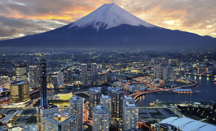
Tokyo is the capital city of Japan and the former most populous city in the world. The metropolitan area is actually the most populated metropolitan in the world, but Tokyo is not the most populated city. The metropolitan area is home to over thirty seven million people.Tokyo is commonly known as a city, but is officially known as a metropolitan prefecture. This title is unique to the metropolitan area of Tokyo.

Tokyo is home to hot, humid summers and generally cool, mild winters. Throughout the course of the year the temperature ranges only about forty degrees variance all year (eighty to forty degrees Fahrenheit). Snowfall is sporadic and scattered scarcely throughout the year, because the temperature in Tokyo rarely drops below freezing. Tokyo is the largest metropolitan economy in Japan and the world. The metro area has a GDP of almost two trillion dollars. Fifty-one of the Fortune 500 businesses are located in Tokyo, doubling second place Paris.  

East Asia

Shanghai

China


Shanghai is the world's largest city with over twenty four million people in the metropolitan area in the world. Shanghai lies on the east coast of China, equidistant from Beijing and Guangzhou. Shanghai experience four distinct seasons, just like most regions in the United States. The city of Shanghai is located on the Yangtze River Delta and is on the coast, touching the East China Sea.

Due to the city's location it is quite susceptible to typhoons and other storms. Shanghai is the cultural and financial center. The city is home to world's busy port. As of 2014 the port in Shanghai exported over twenty nine million TEU's (basic unit for cargo capacity). The city takes on a good majority of the China's booming businesses and economic stimulus.  


Monday, December 5, 2016

South Asia Part Two

New Delhi 

India


New Delhi is the capital of India and has only been the capital of India since 1931. Previously, the capital was Calcutta until the British regime of the early 1900's. Delhi had previously served as a financial and cultural center for the country. The British figured that Calcutta would be logistically much easier to make the capital, due to its location.  


The metropolitan area only takes up sixteen square miles. The city is almost completed surrounded by mountains and changes in elevation. The city suffers from constant earthquakes due to the location over multiple faults. The temperature of New Delhi is almost always warm, averaging over one hundred degrees Fahrenheit throughout the summer months. A majority of India is located in a very humid sub-tropical region creating humid monsoonal summer and a relatively dry winter. India is known for awful air quality, New Delhi is no exception. In 2014 WHO (World Health Organization) ranked New Delhi the city with the worst air quality.    

Friday, December 2, 2016

South Asia

Mt. Everest 

Nepal

Mount Everest is earth's highest peak, located in Nepal. Mt. Everest is not earth's tallest peak, to common misconception. The earth's tallest mountain is Mauna Kea is the world's tallest mountain, it stretches from the ocean floor to thirteen thousand feet above sea level, making it the tallest (over thirty-three thousand feet). Mt. Everest stretches from the ground level to over twenty-nine thousand feet in the air. The majority of the mountain is located in the country of Nepal but the peak crosses the international border between Nepal and China. The other portion of the mountain runs through the Tibet state of China. 


Mt. McKinley in Alaska is also taller in total height than Mt. Everest as well. The weather of Mt. Everest has been known to have harsh and extreme weather.  Winds have reached up to one hundred seventy-five miles per hour. The higher the elevation the less the air that is present, scientists believe that the constant winds on Everest actually increase the amount oxygen in the air. They believe the constant winds help the climbers adjust to the lack of oxygen. The temperature has been known to stay below zero degrees Fahrenheit throughout the entire course of the year.  

Monday, November 21, 2016

Central Asia Part Two

Baku

Azerbaijan

Image result for baku


Baku is the capital and largest city in Azerbaijan. The city is located on the coast of the Caspian Sea, and is one of the lowest lying countries. It is home to over two-hundred million people, it is estimated that only one-fourth of the population lives in the urban area. Baku is a popular host city, it has held multiple events over the last ten years including 2016 European Grand Prix. 

Image result for baku

Baku is in a semi-arid climate, consisting of warm, dry summer and very occasionally a wet winter. Baku is home to strong winds all year round, leading to the nickname "City of Winds". Winds in Baku have reached eighty-nine miles per hour. Summers in Baku average about eighty degrees Fahrenheit. Annually the city receives less than nine inches. Islam is the dominant religion like most countries in the region. The country of Azerbaijan is among the world leader's in petroleum production. My favorite part of Baku, are the Flame Towers, pictured above. We were lucky enough to stay in the hotel portion of one tower, the towers also contain apartments and office space. 

Friday, November 18, 2016

Central Asia

Image result for bukhara


Bukhara

Uzbekistan

Bukhara is a city in the country of Uzbekistan. It is home to only two hundred-sixty thousand people. The city is home to one hundred-forty architectural monuments. Bukhara is the fifth larges city in the country, the city lies in the middle of the silk road. It has served as a center for trade, culture and religion. Islam is the dominant religion of the entire region and the country. Uzbek a form of Arabic is the official language of the country and city. Tajik is also a popular dialect in the city. Most sources disagree with the census, most believe that a good majority of the city consist of Tajiks. 


My favorite monument was the tower Kaylan Minaret, it also known as the tower of death. It was believed that criminals were thrown of the top as their punishment. Minaret is an Arabic word meaning lighthouse. The minaret is pictured below. The tower is almost one hundred-fifty tall, consisting of brick.  

Image result for kalyan minaret

Russia Part Two

Chechnya

North Caucasus, Russia

Image result for chechnya land

Chechnya is located in North Caucasus, Russia. It is located sixty miles from the Caspian Sea, the capital is Grozny. Demographers are not exactly sure of the true population of Chechnya. After the split of the U.S.S.R. Chechnya was split into two halves. The republic of Ingushetia and the Chechen Republic. Chechnya has suffered from two civil wars. Over sixty five percent of the citizens live reside in a rural area, with only five cities with twenty-thousand residents or more.

Russian is the official language of Chechnya. Islam is the predominant religion of the region. The federal republic has suffered from many separatist and revolutions since the 1990's. The Chechen government is currently headed by a once separatist leader.   

Monday, November 14, 2016

Russia

Siberia

Russia

This week we are in Siberia. Siberia is also known as North Asia, extending from the Ural Mountains to the Pacific basin. Siberia extended southward down Kazakhstan and northward to the Artic Ocean. Siberia is over thirteen million square miles of land, home to over forty million residents. Siberia is very  sparsley populated. Siberia accounts for almost eighty percent of Russia's land area.

Siberia is home to many different biomes: coniferous forest, taiga, tundra, and mountainous regions. A majority of Siberia is located in the Aritc circle, leaving long, cold winters and short summers. Siberia has reached eighty nine degrees below zero in the winter of 1933. Siberia is also home to the Siberian tiger, an animal that is close to being extinct.

Friday, October 28, 2016

Europe Part Two

Florence

Tuscany, Italy


Florence is the capital of Tuscany, and is the largest city in Tuscany. The metropolitan is home to over 1.5 million people. Florence was a center of trade and was one of the wealthiest cities in medieval times. It was also believed to be the birthplace of the Renaissance. Florence ranks in the top one-hundred cities in terms of amount of tourism. 


http://www.venice-italy-veneto.com/images/pasquale-amalfi2edit.jpg


Florence is one the cooler cities I have visited. It averages about sixty-two degrees Fahrenheit. The summers in Florence are much warmer and cool down in the winters. Almost every year Florence will receive small amounts of snow. My favorite part of Florence was the vibrantly colored buildings on the cliff sides. 

Thursday, October 27, 2016

Northern Africa Part Two

Casablanca

Morocco


Casblanca, Morocco is the largest city in Morocco, it is located in central-western part of the country. Casablanca is a hub for not ports and is home to one of the largest fininacial centers in Africa. The metropoliatan area is over six-hundred square miles. The city is home to over four million poeple. The city averages over eighty degrees Fahrenheit throughout the course of the year. It is said the weather in Casablanca is very similar to weather of Los Angeles, and the rest of coastal southern California. 

Over fiffty percent of the country's industry is run through the Casablanca. Casablanca's largest export is phosphate, some of the others large exports are fishing, furniture production, glass and textiles. 

Europe

Monaco

France

Monaco is a micro-state or city-state located off the French Rivera in western Europe. France forms three of sides to Monaco's border, the Mediterranean Sea forms the fourth. Monaco is less than a square mile in size and is home to almost 40,000 people. Monaco is the second most densely populated country in the world. Monaco is known for its luxuries and wealth, thirty percent of the population are reported millionaires.


Monaco ranges throughout the year from fifty five to seventy five degrees Fahrenheit. The majority of people in Monaco speak Italian, which I thought was odd. Even though Monaco is located pretty much equidistant from both France and Italy, I just assumed most of the people spoke French.  

Tuesday, October 25, 2016

Southwest Asia

Abu Dhabi

United Arab Emirates

Image result for abu dhabi


Abu Dhabi is the most populous city in the country of the United Arab Emirates, it is also the capital city. It is home to over 1.5 million people, making it over two-thirds of the country's economy. Abu Dhabi is one of the richest cities in the world. It ranks as the fourth most expensive city in the region, it also has a GDP per capita of over 61,000 dollars. 

Image result for palm jumeirah

Abu Dhabi is located in the northeastern part of the Persian Gulf, in the Arabian Peninsula. The city is on an island that is less than two hundred fifty square kilometers. The city averages over one hundred degrees Fahrenheit over the summer months. My favorite place in Abu Dhabi was Palm Jumeriah Island. It is one of three man made, government owned island of the coast. The island production started in 2001 and was finished in 2006.

Monday, October 24, 2016

Northern Africa

Atlas Mountains

Morocco

 Image result for atlas mountains


The Atlas Mountain Range stretches over 16,000 miles throughout the countries of Morocco, Algeria, and Tunisia. The highest peak in the range is Jebel Toubakal, which is over 13,000 feet tall. The mountain is specifically in the southwest corner in Morocco. The mountain separates the Mediterranean and the Atlantic coasts. The Atlas Mountains are home to many endangered species, unique to Africa. 

Image result for atlas mountains

The Atlas Mountains are home to loads of iron, lead, silver, rock salt and marble. The mountains are believed to be formed during the Precambrian period. The were formed when the Americas and Africa collided. The Appalachians were also formed from the Americas and Africa colliding. The Atlas Range once rivaled the Himalayas is size and stature, but have decreased in size over time.  

Friday, October 14, 2016

Sub-Saharan Africa Part Two


Sao Tome and Principe

Gulf of Guinea, Africa

Sao Tome and Principe are Portuguese speaking island one-hundred forty miles  northwest of Gabon. Sao Tome and Principe are the two main islands, they are believed to be uninhabited until Portuguese explorers discovered the islands in the 1400's. The Portuguese used the island extensively for slave trade in the years following. The island naturally was a hot spot for cultivating sugar, coffee and the coca plants. The island of Sao Tome is only about four-hundred square miles of land, inhabited by almost 200,000 people.  The two main islands are about ninety miles apart. 


The islands are made up mostly of lush tropical forests. The islands were formed from volcanoes. My favorite part of the island was the bananas. The guides let us pick some bananas, and we brought them back and cooked them. They were super tasty. 

Thursday, October 13, 2016

The Caribbean Part Two

Abaco Islands 

The Bahamas

Image result for the bahamas

The Abaco Islands are the main islands in the Bahamas. They are in the northern portion of the Bahamas, one-hundred eighty miles east of the southern tip of Florida. The main two islands are the Great and Little Abaco. Unlike much of the Bahamas and the beaches of south Florida, most of the islands are comprised of limestone. Most beaches are white sand, and the Abacos are home to the third largest barrier reef in the world. The first believed European settlers were colonists fleeing from the American Revolution in the 1780's. 


My favorite part of the Abaco Islands was the pigs on the beaches and in the water. The pigs were super friendly almost like they were domesticated animals. The Abacos are famous for their boat and ship building abilities, they also are home to super large ports. Hope Town had a really cool red and white striped lighthouse. It looked really similar to the lighthouse in Harbor Town, South Carolina.  

Tuesday, October 11, 2016

Sub-Saharan Africa

Victoria Falls

Livingstone, Zambia

Victoria Falls is a waterfall of the Zambezi River on the borders of Zambia and Zimbabwe. Victoria Falls are nor the widest or the tallest waterfalls in the world, but it is the largest. The falls are the largest falling sheet of water in the world. It is almost twice the size of Niagara Falls. The river is very unique due to the fact that it does not river through a mountain or hill. The river runs through a shallow plateau of basalt rock. The falls are just a single drop, 6000 feet wide and almost 400 feet tall. The falls move over 38,000 cubic feet of water a second. 

  
http://vizts.com/wp-content/uploads/2016/04/Victoria-Falls-amazing-view.jpg

My favorite part of the falls was the Devil's Pool. The Devil's Pool is a little area on top of the falls, that a little pool has formed. The pool is only present during the dry season, and we were able to go swimming. The guides told us the pool would be very fatal for anyone to enter in the wet season. It was an amazing view from the top of the falls. We looked down and 400 feet below was the water. The water was also super warm.
Image result for devils pool

Thursday, October 6, 2016

Caribbean

Turks & Caicos
The Bahamas 

Image result for turks and caicos


The Turks and Caicos islands are a set of islands north of Hispaniola (Dominican Republic and Haiti) in the Bahamas. Turks and Caicos is about six-hundred miles to the southeast of Miami, Florida. The islands only have about 170 square miles of land. The islands are quite populated, being as small as they are. They are home to over 30,000 people. The Spaniards first discovered the islands in 1512. Many different countries once gained control of the islands. Turks and Caicos ended up under the power of the British Empire at the height of its Empire. They were completely uninhabited by the year 1513 due to the Spaniards enslaving the native peoples. Therefore, the islands served as discreet hiding places for pirates


The Turks and Caicos islands are made of eight main islands, and two-hundred nighty-nine other smaller islands. The smaller islands consist of marshes, swamps, and lots of beach fronts. The islands are very close to the equator, so the average monthly temperature ranges from eighty-one to eighty-eight degrees Fahrenheit. The region the islands are in makes them prone to lots of hurricanes and smaller tropical storms. 

Monday, October 3, 2016

Latin America Part Two

Angel Falls

Bolivar State, Venezuela


Angel Falls is the tallest waterfall in the world. It is located in Bolivar State, Venezuela. Angel Falls is over 3,200 feet tall, the water actually only falls about 2,600 feet. The falls are on the Auyantepui Mountain. The falls are named after Jimmie Angel, who was the first aviator to fly over the falls in 1937. To the Spanish speaking world Angel Falls in known as Salto Angel. The Rio Kerepacupai Meru supplies the water for the falls. Angel Falls is over fifty-two times higher than Niagara Falls.


The first accountants of the falls are in 1912. Venezuelan Explorer Ernesto Sanchez La Cruz first came upon this massive waterfall.  Angel Falls is the top tourist attraction in Venezuela, even though the falls are located deep into the Venezuelan jungle. Angel Falls also appears in the Disney movie "Up". Angel Falls is located in the Canaima National Park. The park reaches border with both Brazil and Guyana. The park is the sixth biggest in the world, covering an area equivalent to the size of Maryland.  

North America Part Two

Vancouver
British Columbia, Canada 


We just got back from Vancouver. Vancouver is the most populated city in the British Columbia province. Vancouver is the most diverse city in Canada, over half of the population's first language is not English. Vancouver is only about thirty-five kilometers north of the American Border. Vancouver is said to be one of the most livable cities in the world. Due to livability of the city, many conferences events are held in Vancouver annually. 

https://upload.wikimedia.org/wikipedia/commons/8/80/English_Bay,_Vancouver,_BC.jpg

My favorite place in Vancouver that we went was English Bay. English Bay is on the west side of Vancouver's coast. We were fortunate enough to be walking through the night before the Celebration of Lights Festival. We went back the next night for the festival and watched some fantastic fireworks. We also learned about Joe Fortes, who was the one the first lifeguards in Canada. He taught hundreds of people how to swim while keeping the beaches safe. The beach is still recovering from an oil spill that took place last April. The spill was well contained and damage was limited to a minimal.


Monday, September 26, 2016

Latin America

Mount Fitz Roy

Santa Cruz, Argentina


This week we visited Latin America. Our favorite place we visited was Mount Fitz Roy in Argentina. Ftiz Roy is located in the southwest corner of the Santa Cruz province, on the Chilean border. The peaks pictured above are actually the inspiration behind the Patagonia brand logo. We learned that Mount Fitz Roy was named after Captain Robert FitzRoy, whom was the Captain of the HMS Beagle. 


Image result for Mount Fitz Roy, Argentina


The mountain is made of granite rock. Due to the vertical faces and often brutal weather, scaling Fitz Roy is quite difficult. Fitz Roy is in a very isolated part of the country. On average the mountain will only yield one successful climb a year, while Mount Everest may yield a hundred a day. The closest city to Mount Fitz Roy is El Chalten, which is thirteen kilometers to the southeast.   

Thursday, September 22, 2016

North America

Schlitterbahn

New Braunfels, TX

Today we went to the Schlitterbahn water park in New Braunfels, TX. New Braunfels is a town of 63,000 people located about thirty miles north east of the San Antonio metropolitan area. The Schlitterbahn water park is seventy acres that uses the water from the Comal River, located just to the southeast of the park. The water park is a neat experience because some of the water comes out the Comal River. The water is surprisingly clean, for being river water.

My favorite ride we went on was the Raging River Tube Chute. It was forty-five minutes of tubing down a lazy river type ride. It was a very unique ride, the Tube Chute was lazy for a portion of the forty-five minutes, while we worked our way around the river and the park. The last fifteen minutes of the Tube Chute were very intense and fun. We also enjoyed the the wave pool pictured below. 


Image result for schlitterbahn new braunfels lazy river